|
|
Day
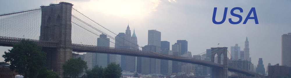
17 (June 22, 2008) Mariposa Grove and arrival to San Francisco
Before
Leaving Wawona Hotel to South, in our way to the
Yosemite
N.P. exit, we still will have a last visit on it: Mariposa Grove. There
we will walk through giant Sequoias to be amazed by the biggest living
being in the planet. After this visit we will go for the 4 hours’ drive
to San Francisco, where we will try to enter by Golden Gate Bridge. If
we were with time enough we could stop in Sausalito and if it was at
lunch time we could enjoy the seafood there. Once in the city, we would
look for good views of the bridge and go to Golden Gate Park to visit
the Japanese garden and see the bison in the field they have in that
same park. All this before leaving our bags in the hotel and delivering
the car.
|
After
What a nice sleep this night! Mountain is so quiet at night.
Unfortunately there is no track of bears, I would wish to see one on
despite of all the warnings; or, at least, sensing the presence of one.
Anyway, we use the common showers and go
downstairs for breaking our fast. Breakfast is great with a lot of the
things I like: eggs, sausages, bacon, etc… (I’m not a person for only
sweet food). As it is a buffet I’m going out twice my size.
Once in the car, we’re going on to South by the
same road we came yesterday. The ride until Mariposa Grave junction is
short and a few minutes later we’ve parked in the earth area where the
road dies. The slots are marked using tree trunks, but they’re not from
here. I know that because these are trunks of a regular size pine trees
while the trees around are ten times bigger at least.
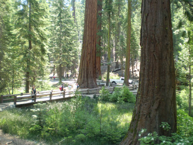
It’s clear we’ve reached the Sequoia place, just
in the parking there is one with its ten meters of perimeter at a
guess. This is the start of a track to explore this forest so special.
Just at the beginning there is a hut with information and maps that you
can take. Their price is 50 cent, which you should put inside a box. I
can see it is a 10 kilometers return track so I can say now we’re not
going to do it entirely. There is a smaller track, 3.5 Km. We may do
this, let’s see.
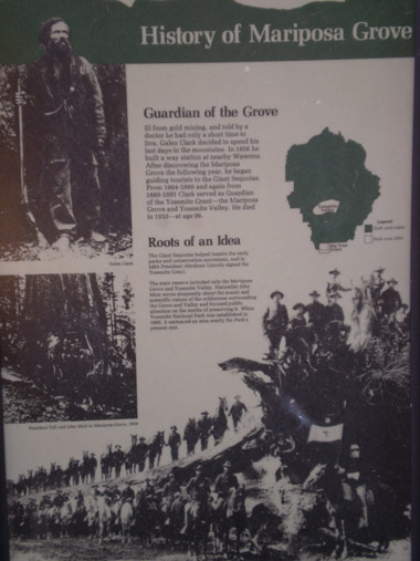 The
historical photo in the front of the brochure is quite impressive as
shows the Sixth Cavalry posing with a fallen sequoia. All of them!! The
historical photo in the front of the brochure is quite impressive as
shows the Sixth Cavalry posing with a fallen sequoia. All of them!!
You feel absorbed from nature in a few seconds of starting
the track, which snakes between huge trees through wooden bridges over
the streams. You feel like in a bigger scaled forest, so you’re smaller
than usual here. Like Ewoks, which forest used for filming was one
similar to this one, only closer than San Francisco.
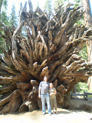
Just after a short walk we find the first wonder:
The Fallen Monarch. This is the fallen sequoia from the historical
picture, which incredibly has not changed with the years. You can check
that in the pictures, like if it is so much wood as per insects could
rot it. We pose too with the awesome massive roots.
We go on walking through this forest which makes
us feel like
gnomes as we keep looking up all the time, where the top of these trees
appear far. There are signs along the track showing the distance to the
highlights. I would like to reach the trunk a tunnel was made for
wagons first, and cars later, could go through. Meanwhile we’ve reached
the next highlight: “Bachelor and three Graces”. This is a big sequoia
with three thinner ones close around it. A lot of imagination for this
name!
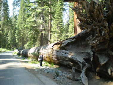
Later we find a couple of fallen trees over the
path, which have been cut by the middle in order people can pass
through them. It allows checking the diameter, which must be around two
meters, and the ring system showing the age of these trees. It can take
a whole life counting them so the ages are given approximately: two
thousand something years.
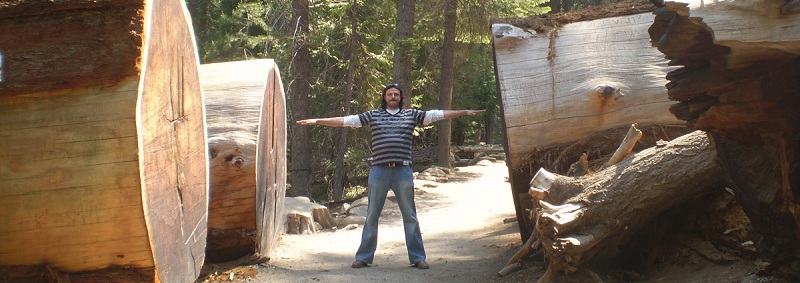
We’ve been walking one kilometer and women ask me
where I want to end our track. When I answer I would like to reach the
tunnel tree they point me a sign saying it is still 5 Km further. So we
walk just a little more, enough as per seeing the Grizzly Giant - the
biggest sequoia in the park – and turn around for going back to the
car. I think I won’t have the chance again of seeing so big trunk that
a tunnel should be made through it for letting vehicles to pass,
although I’m thinking too 5+5 are 10, and no way of walking 10 fucking
kilometers this beautiful morning.
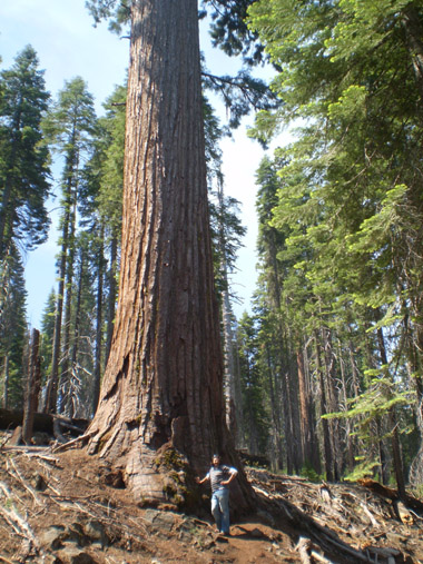 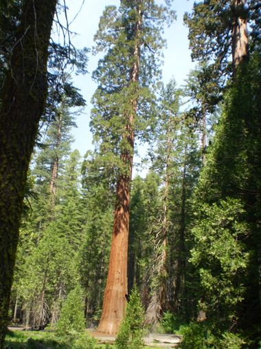
I’m a big person, so imagine how small I’m feeling in the
picture at left.
After I would find out there are actually two
tunneled trees in the park and one of them was really close to the
Grizzly Giant. But with no chance of coming back we enjoyed this walk
by this fairy tale forest.
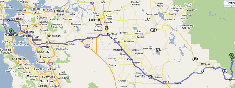
Once in the car we go fast as we want to reach
Sausalito at lunch time and it’s 11:30 AM now. Just a few minutes later
we pass by the exit of the park, which is the main entrance too, and we
can see the welcome sign for the incoming cars. As it was no sign in
the road we used to getting in – or we just missed it - I stop for a
picture with it. The logo is representing a landscape identical to one
picture we did yesterday. Judge yourself
:
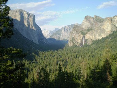 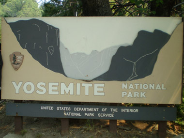
Identical, aren’t they?
We pass by Oakhurst soon, our first city since we leave
Bishop yesterday morning. It’s small and looks like a typical mountain
town. Main road is full of stores and gas stations and I stop in one of
them as today is the day we must deliver the car and we should do that
with the tank as empty as possible so I’m thinking about spending my
last dollars in fuel, 40 specifically. Then I look for the “shortcut”
I’m bringing printed from Google Maps with a route through secondary
roads until Merced. Now I’m hearing myself, it sounds like we’re going
to get lost for hours.
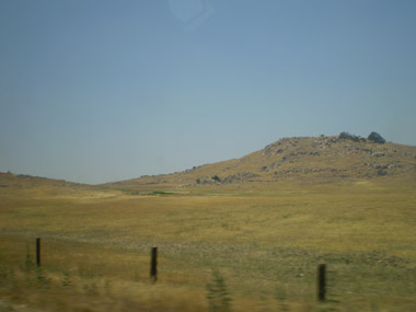 I drive between large ranches with intense yellow grass where
we cannot see the houses, which will be far from the boundaries marked
with a three wired fence. We don’t see anybody and there are no signs
to check we’re on the right way so every time I think we’re getting
more lost until we reach a city and it is actually Merced, the one I
was expecting to arrive. I think we’ve been so lucky here.
I drive between large ranches with intense yellow grass where
we cannot see the houses, which will be far from the boundaries marked
with a three wired fence. We don’t see anybody and there are no signs
to check we’re on the right way so every time I think we’re getting
more lost until we reach a city and it is actually Merced, the one I
was expecting to arrive. I think we’ve been so lucky here.
I drive by the side of the highway until I can
join it. We pass by Modesto and exit in Manteca for taking route 205
which goes directly to San Francisco. It’s clear the names of the
cities were set by Spanish people but I cannot explain why they choose
these words. Did they chose just random words starting by M? We’ve
passed by Mariposa (butterfly), Merced (favor), Modesto (modest) and
Manteca (butter) and would pass by Madera (wood) if avoiding the
“shortcut”
.
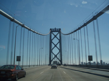 I’m sensing close to the Bay City three hours later: more
cars,
landscape changed from fields to buildings and exits more often in the
highway. The first exit I can identify is the one saying something
about Oakland. I must pay attention if I want to take the Golden Gate
Bridge. I finally take one saying something about a bridge and I get in
a mess for a bit, but ending in a bridge, only I don’t know which one.
Golden Gate is red and this is grey, but it could be the right way
anyway as I must take a bridge to get the Sausalito area before getting
into Golden Gate. This bridge ends, but we immediately get into another
one, a very long one. We can identify San Francisco skyline at our
right. I cannot tell if this is good or not.
I’m sensing close to the Bay City three hours later: more
cars,
landscape changed from fields to buildings and exits more often in the
highway. The first exit I can identify is the one saying something
about Oakland. I must pay attention if I want to take the Golden Gate
Bridge. I finally take one saying something about a bridge and I get in
a mess for a bit, but ending in a bridge, only I don’t know which one.
Golden Gate is red and this is grey, but it could be the right way
anyway as I must take a bridge to get the Sausalito area before getting
into Golden Gate. This bridge ends, but we immediately get into another
one, a very long one. We can identify San Francisco skyline at our
right. I cannot tell if this is good or not.
We end at feet of Transamerica tower and now I know we’ve
reached
our destination, and I also know we won’t ever lunch in Sausalito. New
problem: I haven’t got any map from Financial District, the one where
we are. So a 4 hours’ drive so good in orientation will finally have a
crappy end.
I’m going to explain the next the most brief and optimistic I can: I
offer a tour by San Francisco downtown, repeating our pass by the most
iconic buildings, until finding the way of escaping from the one way
streets making us driving circles. I finally find Columbus Avenue,
which that long as per appearing in the map I’ve brought. So now we
know where we are and how to reach the hotel I park the car to lunch
somewhere here, at 4 PM. We go into a place called Burger Meister and
get three burgers served in a basket with a lot of fries and some
salad. Delicious! Around 20€ for all three. I ask directions to the
young woman about our next plan as I don’t want more “tours” today.
We’re going to check in at hotel and leaving the baggage in there and
then driving to the Golden Gate to see the bridge and visiting a couple
of spots in the park, as this is the furthest place to visit in this
city,: the Japanese Garden and the Bison Paddock. Then we will deliver
the car. And we have two hours and a half to do that.
 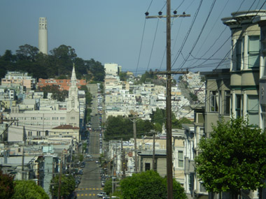
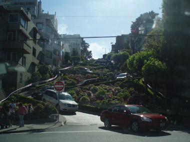
We reach the hotel with no issue and Castle Inn
rooms are not disappointing. With no baggage we take the car directly…
directly to the orientation mess. Sea use to be a good reference, but
not here, as it can be seen from anywhere. Lombard Street is a main and
long street but it has a touristic part popular for being one of the
steepest streets in the world and the problem is this specific part is
in the opposite direction of the whole street so I’m forced to turning
when I want to go straight. We take the advantage of being here to take
some pictures, though. We reach Golden Gate area after several turns.
We could see in our way how good is the 4WD car on this city as
starting the car in a steeper street is not an issue with these.
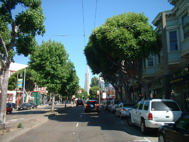
In our way to here we could see the typical streets and
buildings
of this city, some paintings in walls… but I didn’t expect Golden Gate
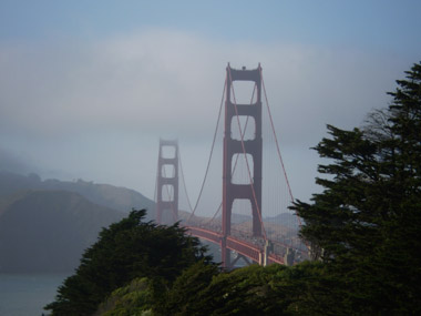
was so difficult to see. We know we’re now close to the bridge, but
this is an area with a large park and highways. We leave the one we’re
driving through in the last exit as I could read it goes directly to
the bridge and we should pay the toll twice for a return trip. But
still, the trees are hidden the bridge until we pass by a place with no
trees where the red bridge can be seen. We stop and take some pictures
here. When we’re driving to the park, I’m thinking about coming to
somewhere with different views of the bridge.
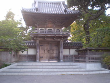
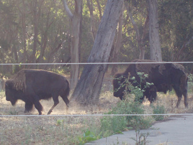
We take a while for finding the entrance to the park but once inside we
can see the Japanese Garden entrance as shown in the picture at left:
closed. Now we just have to find the bison and, again, we take a while
for finding them in the opposite side of the park. We cannot see
anybody around and I can feel how the time is pressing us for
delivering the car on time in O’Farrell Street.
That street is close to Union Square, so I must take Oak,
then
Market and O’Farrell from there… it seems easy… or not. I don’t
understand how easy I can get lost in this city where the blocks are
square as in Barcelona, but the one way streets are “driving” me crazy
here! Some part of uselessness from my part will do the work too. The
thing is when I was driving by the street I wanted I’m forced to turn
and then I get into the maze again. Is amazing how easy I can pass from
“I’m going fine” to “Where the hell am I?” in this city. Is not a
surprise the place is closed when we arrive, we ask to a kind of guard
of this parking and he confirms we must come back tomorrow. We thought
about coming back to the hotel using the most popular tram, but it must
wait for tomorrow too. I’m out of fuel, that’s the only thing I’ve done
well with the car today, but I must put some for this extra day. get into the maze again. Is amazing how easy I can pass from
“I’m going fine” to “Where the hell am I?” in this city. Is not a
surprise the place is closed when we arrive, we ask to a kind of guard
of this parking and he confirms we must come back tomorrow. We thought
about coming back to the hotel using the most popular tram, but it must
wait for tomorrow too. I’m out of fuel, that’s the only thing I’ve done
well with the car today, but I must put some for this extra day.
We come back to the hotel, which fortunately has free
parking, to rest from this long day. Night fell in our way and we just
buy some sandwiches and fruit nearby for dinner in our rooms. I’ve got
the feeling my work is not well done for San Francisco: at the moment
we reached the city – from the wrong entrance, by the way – we’ve got
into a chaos for the visits. I must prepare the route for tomorrow for
avoiding what happened today but, at least, we’ve got the advantage of
having still the car, which is a great help in this city.
One last thing: for the first time in this travel around USA, it’s so cold!
|
|
|
|